
Sponsored
Search results
-

New Bronco Owner from Colorado! Happy to be here!
Yo! I've watched a lot of videos on your YouTube channel https://www.youtube.com/@Colorado4x4 Glad to hear you switched over to the Bronco! I am in SLC but I travel to CO a few times a year - was there for 4th of July weekend. Can't wait for Black Bear Pass to open!- BroncoTrail
- Post #8
- Forum: Introductions & Welcome Center 👋
-
Carplay / Android auto issues - a survey
It's annoying as !%@$#. I have a 12" screen and use Android Auto and it's such a pain in the @$$ to get it to connect sometimes. Or sometimes it'll disconnect for no reason and I can't get it to reconnect. I use it wirelessly, so my Bluetooth and Wi-Fi need to be enabled. I do have to... -
Need some advice from those who know more than me please :D
I've never been to that area but looks like there is some off-roading for sure. -
Detailed maintenance schedule for frequent off-road use
Is that overkill? Does it only need to be done if the vehicle isn't driving perfectly straight? -
Detailed maintenance schedule for frequent off-road use
I've been off-roading almost every week including mud, dust, dirt, rocky terrain, and water crossings. I'd like to put together a detailed maintenance schedule to follow, but I'm no expert. How does this look so far? Please feel free to make suggestions - your input is welcome. Every 5,000... -
What are the Amazon prime day deals you are looking for.
Are you looking for a dashcam to run 24/7/365, or one to just capture certain footage on-demand?- BroncoTrail
- Post #21
- Forum: General Bronco Topics
-
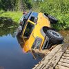
You've probably already seen my Bronco underwater on the web?
I saw it on Facebook and I also saw some of the a-holes who were bashing you. I can't stand those losers, just ignore them. Not everything goes as planned or works correctly and sometimes things will go south.- BroncoTrail
- Post #32
- Forum: Photos / Videos
-
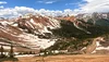
Colorado Passes: Engineer -> Cinnamon -> California -> Hurricane -> Corkscrew
Hey I'm with ya. Carrying doesn't mean paranoid or ill-informed, it means being prepared.- BroncoTrail
- Post #42
- Forum: Photos / Videos
-
Colorado Passes: Engineer -> Cinnamon -> California -> Hurricane -> Corkscrew
I pretty much agree with you, but let me ask, how about if you're in the middle of grizzly territory in Montana, 30 miles away from any sort of town, with your wife and kids? Would you bring a firearm and bear spray in that situation?- BroncoTrail
- Post #40
- Forum: Photos / Videos
-
Colorado Passes: Engineer -> Cinnamon -> California -> Hurricane -> Corkscrew
I got very close to the top of Yankee Boy Basin but stopped where the snow was on the trail. Didn't feel like creating any projects for myself plus I was alone. Although there was another dude that showed up about ten minutes after I did and he had a winch also, but neither of us was 'bout...- BroncoTrail
- Post #34
- Forum: Photos / Videos
-
Colorado Passes: Engineer -> Cinnamon -> California -> Hurricane -> Corkscrew
Firearms aren't necessary at all in terms of wildlife. Black bears would be the biggest threat and the chance of you seeing one is slim to none. And even if you do they won't bother you. If you're sleeping in a tent, keep all the good smells in your vehicle. Bear spray is a better defense...- BroncoTrail
- Post #31
- Forum: Photos / Videos
-
Colorado Passes: Engineer -> Cinnamon -> California -> Hurricane -> Corkscrew
Tbh I'll never even attempt to use that garbage lol. After 7+ years of using various GPS apps, I know the Bronco app will never come close to these companies that specialize in it. I went to Patagonia to hike and Gaia GPS even showed small spur trails that lead to glaciers that you couldn't...- BroncoTrail
- Post #29
- Forum: Photos / Videos
-
Colorado Passes: Engineer -> Cinnamon -> California -> Hurricane -> Corkscrew
@buzpro Here is what it'll look like when you load the GPX file.- BroncoTrail
- Post #26
- Forum: Photos / Videos
-
Colorado Passes: Engineer -> Cinnamon -> California -> Hurricane -> Corkscrew
A GPX file is the exact route that I took. You load/import it into GPS mapping software. It's pretty easy actually. I recommend using an app (and website) such as Gaia GPS to open the file. You can also use the AllTrails or onX Offroad app. Gaia GPS should have a free version that you can...- BroncoTrail
- Post #25
- Forum: Photos / Videos
-
Colorado Passes: Engineer -> Cinnamon -> California -> Hurricane -> Corkscrew
Here ya go. That'll be $49.99.- BroncoTrail
- Post #23
- Forum: Photos / Videos
-
Colorado Passes: Engineer -> Cinnamon -> California -> Hurricane -> Corkscrew
LOL well at least you gave it an attempt! 6" of ground clearance is definitely insufficient hah. We gotta get a Bronco group together and tear up CO one year! I know it's a far drive for you but you can swing it ;) P.S. I didn't air down my tires while driving between trailheads - hope...- BroncoTrail
- Post #17
- Forum: Photos / Videos
-
Colorado Passes: Engineer -> Cinnamon -> California -> Hurricane -> Corkscrew
I would say so, yes.- BroncoTrail
- Post #5
- Forum: Photos / Videos
-
Colorado Passes: Engineer -> Cinnamon -> California -> Hurricane -> Corkscrew
I forget exactly which photos are from where... and I actually I just realized that some photos are from Yankee Boy Basin. But if you have any questions at all I'd be happy to help. You could do all five passes from Ouray -> Lake City -> Ironton in one day for sure, but I'd recommend two days...- BroncoTrail
- Post #3
- Forum: Photos / Videos
-
What did you do TO / WITH your Bronco today? 👨🏻🔧🧰🚿🛠
Went to Colorado! More pics here: https://www.bronco6g.com/forum/threads/colorado-passes-engineer-cinnamon-california-hurricane-corkscrew.76762/- BroncoTrail
- Post #6,117
- Forum: General Bronco Topics